Terroir & Vineyard

Houtvillers

Hautvillers

INFORMATION

Damery

INFORMATION

Grauves

INFORMATION

Mancy

INFORMATION

Hautvillers

Key facts

Located in subregion / area: Vallée de la Marne / Grande Vallée de la Marne

Classification: Premier cru (93%)

Vineyards and grape varieties: 284.1 hectares, of which 45% Pinot Noir, 33% Pinot Meunier, and 22% Chardonnay.

Noted for: Pinot Noir and Pinot Meunier from south-facing slopes, the Benedictine abbey Saint-Pierre d’Hautvillers where the monk Dom Pierre Pérignon worked as winemaker.

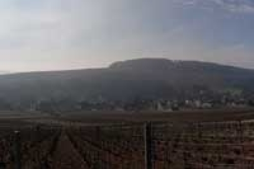
Hautvillers is most known for its abbey, where the monk Dom Pierre Pérignon was active, and many visitors to the region pass through here. The village calls itself le Berceau du Champagne, “the cradle of Champagnes”.

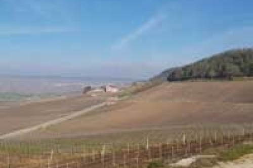
The Hautvillers commune covers 1177 hectares and counts 768 inhabitants (as of 2011) called Altavillois and Altavilloises respectively. This is derived form the old Latin name of the village, Alta Villare.  The Saint-Pierre d’Hautvillers Abbey is located at the southwestern edge of the village. It was founded in the year 650 by Saint Nivard, archbishop of Reims. The abbey had a relic of Saint Helena, nicked in Rom in the year 841 by a priest from Reims. This meant visits by pilgrims and income that made the abbey able to buy vineyard land. The abbey buildings have been destroyed and rebuilt several times throughout the history of its existence.

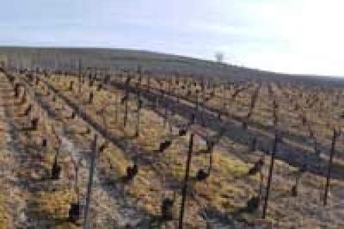
Similar to other abbeys and other church property in France, the French Revolution of 1789 meant an end to its activities, and the property was confiscated by the state. The (former) abbey buildings are today owned by Moët & Chandon. Vineyards consists of predominantly south-facing slopes, mostly with mixed Pinots.

The current vineyard surface in the commune is 284.1 ha (702.0 acres). There are 127.5 ha Pinot Noir (44.9%), 93.3 ha Pinot Meunier (32.8%), 62.9 ha Chardonnay (22.2%). Numbers from CIVC, as of 2013. In 1997, the vineyard surface was 280 ha. There are 140 vineyard owners (exploitants) in the commune.

Champagne houses that use vineyards in this village include Moët & Chandon, Roederer, and Taittinger.

Earlier, at least until the early 1990s vintages, the small brochure that accompanies gift boxes of Dom Pérignon, specified from which villages the grapes to the cuvée came. It used to be mostly a number of grand cru villages and Hautvillers, to provide a connection to the place where Dom Pérignon himself was active.

Source: winetomas 

Damery

Key facts for Damery

Located in subregion/area: Vallée de la Marne / Vallée de la Marne Rive Droite

Vineyards and grape varieties: 407.5 hectares (1006.7 acres), of which 61% Pinot Meunier, 21% Pinot Noir and 18% Chardonnay.
Classification: “Autre cru” (89%)
Noted for: one of the largest villages in terms of vineyard size among the “autres crus”.

Damery is located at the Marne river, on its right bank, which is north of the river. Damery is the easternmost village along the river that isn’t counted as a part of the Grande Vallée de la Marne, which is the wider part of the Marne valley where the premier cru and grand cru villages are located.

The Damery commune covers 1544 hectares and has 1471 inhabitants (as of 2014) called Dameziats and Dameziates. The vineyards in Damery consist of dominating south-facing slopes with Pinot Meunier as the most common grape variety.

In similarity to the neighbouring village, Venteuil, Damery was scored 89% on the now-defunct échelle des crus, which means that these villages just missed out on premier cru classification, which was applied to villages in the 90%-99% range on this scale.

The current vineyard surface in the Damery commune is 407.4 hectares (1006.7 acres). There are 247.8 ha Pinot Meunier (60.8%), 84.8 ha Pinot Noir (20.8%), 73.0 ha Chardonnay (17.9%), and 1.8 ha others (0,4%). Numbers from CIVC, as of 2013. In 1997, the vineyard surface was 382 ha. There are 516 vineyard owners (exploitants) in the commune.

Source: winetomas

Grauves

Key facts

Located in subregion/area: Côte des Blancs / Côte des Blancs

Vineyards and grape varieties: 190.8 hectares (471.5 acres), of which 90.7% Chardonnay, 7.6% Pinot Meunier, and 1.6% Pinot Noir.
Classification: Premier cru (95%)

Grauves is located some 8 km south of Épernay, on the “back side” of the actual Côte des Blancs slope, in a valley formed by the stream Le Darcy. Le Darcy originates in Grauves and flows to northwest into the area Côteaux Sud d’Épernay. A forested area separates Grauves from the other villages in the Côte des Blancs.

Other than the Grauves village itself, the commune also contains the hamlets of Le Grand Pré, Montgrimaux, and Le Darcy.

The name Grauves is derived from the Latin grava, meaning gravel. A local nickname of the village is “Royal Coteau” since forest surrounds surrounds Grauves on several sides, a bit like a royal crown. Actually, a horse shoe would be a better description of the shape of the edge of the forest around the village, but perhaps too prosaic.

The Grauves commune covers 784 hectares and has 675 inhabitants (as of 2012), referred to as Gravriots and Graviotes.The vineyards in Grauves are located around the village, on both banks of the stream Le Darcy. The slopes vary but include southwest-facing slopes on the right bank and northeast-facing slopes on the left bank. Chardonnay is the dominating grape variety.

The current vineyard surface in the Grauves commune is 190.8 hectares (471.5 acres). There are 173.1 ha Chardonnay (90.7%), 14.5 ha Pinot Meunier (7.6%), 3.1 ha Pinot Noir (1.6%), and 0,1 ha other (<0.1%). Numbers from CIVC, as of 2013. In 1997, the vineyard surface was 185 ha. There are 191 vineyard owners (exploitants) in the commune.

The premier cru status

On the now defunct échelle des crus scale, where 100% = grand cru and 90-99% = premier cru, a smaller number of villages had different numbers for white and black grapes, i.e., for Chardonnay and for Pinot Noir and Pinot Meunier. Grauves was one of them, with 95% for white grapes and 90% for black grapes, which in both cases meant premier cru status. Grauves has kept this premier cru following the abolishment of the échelle des crus, just like other villages that achieved it.

Source: winetomas

Mancy

Key facts

Located in: Vallée de la Marne: Côteaux Sud d’Épernay

Vineyards and grape varieties: 188.6 hectares (466.0 acres), of which 52% Chardonnay, 42% Pinot Meunier, and 6% Pinot Noir.
Classification: “Autre cru” (88%)

Mancy is located south of Épernay in a forked valley formed by the two streams Le Darcy and Le Mancy. The actual village is located on the left bank of Le Mancy. The two streams combine in the northern part of the commune where Le Mancy empties into Le Darcy, after arriving there from the Grauves direction.

The Mancy commune covers 357 hectares and has 268 inhabitants (as of 2013), referred to as Mancéens and Mancéennes.

Vineyards

The vineyards in Mancy are spread over the commune, on both banks of Le Darcy and Le Mancy. The vineyards in the western part of the commune are located on slopes on the left bank of Le Mancy, and are continuous with those in Monthelon, Morangis, and Moslins. The vineyards in the central and eastern parts of the commune, between Le Mancy and Le Darcy, as well as a smaller vineyard surface on the right bank of Le Darcy, are continuous with those in Grauves. Due to its location in a forked valley, the direction of the slopes vary, but are mostly southeast in the western part of the commune. Chardonnay is the most common grape variety, but the proportion of Pinot Meunier is only slightly less.

The current vineyard surface in the Mancy commune is 188.6 hectares (466.0 acres). There are 98.2 ha Chardonnay (52.1%), 79.2 ha Pinot Meunier (42%), and 11.2 ha Pinot Noir (5.9%). Numbers from CIVC, as of 2013 In 1997, the vineyard surface was 186 ha. There are 48 vineyard owners (exploitants) in the commune.

Source: winetomas 

Victor & Charles collection

Champagne Le Brut until Le Blanc de Blancs